FAQs | Geospatial Technology & Agriculture Risk Management
Why are satellite images are different than photos?
Satellite imagery captures the light reflecting from crops/plants through a scanner, not a camera. “Bands” are certain wavelengths of light which are captured by the scanner, and a kept as separate files until combined at a later date, in either the form of true colour images (composites), or indices (such as NDVI).
Below is a representation of the reflectance values (blue line) of a healthy crop. You can see on that the healthy crop, there is low blue and red reflectance, and a slight jump in the green band – the reason why healthy crops appear green. The first grey colour band (between 720-900nm) is the Near Infrared (NIR) light, which is beyond our visible spectrum.
NIR is critical for measuring the health, vigour, and biomass of crops remotely. The point at which the blue line jumps rapidly between the red and NIR bands is called the “red-edge”. It is not completely clear as to what the “red-edge” is telling us about a crop, but we are actively researching the applications of this part of the spectrum. Source: Precision Agriculture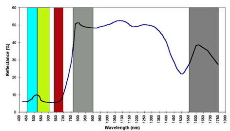
Source: www.cropscan.com
What are Geographic Information Systems?
Geographic information systems (GIS) are a powerful set of tools for collecting, storing, and analyzing spatial data and giving valuable information to natural resource managers. GIS is more than a mapmaking technology. It offers strong analytical capabilities and data storage models that complement other geospatial technologies such as remote sensing and geographic positioning systems (GPS). GIS business is booming worldwide. One study describes GIS software sales at about $US 1 billion annually with another $US 15 billion in associated professional services and related technologies (Longley et al 2001). Other statistics suggest that there are about two billion GIS users worldwide and this figure is growing at about 20% per year (Foresman, 1997). USAID has become an important stakeholder in GIS with application in over 100 projects worldwide since 2000 (NRIC, 2005). As an innovative information technology, GIS has become an important tool for international development and many USAID partners, including governments, non-governmental organizations (NGOs), research institutions, businesses, and local communities share GIS projects and data with the Agency.
How Does Remote Sensing Work?
There are several types of remote sensing systems used in agriculture but the most common is a passive system that senses the electromagnetic energy reflected from plants. The sun is the most common source of energy for passive systems. Passive system sensors can be mounted on satellites, manned or unmanned aircraft, or directly on farm equipment.
There are several factors to consider when choosing a remote sensing system for a particular application, including spatial resolution, spectral resolution, radiometric resolution, and temporal resolution.
Spatial resolution refers to the size of the smallest object that can be located in fields or detected in an image. The basic unit in an image is called a pixel. One-meter spatial resolution means each pixel image represents an area of one square meter. The smaller an area represented by one pixel, the higher the resolution of the image.
Spectral resolution refers to the number of bands and the wavelength width of each band. A band is a narrow portion of the electromagnetic spectrum. Shorter wavelength widths can be distinguished in higher spectral resolution images. Multispectral imagery can measure several wavelength bands, such as visible green or NIR. Landsat, Quickbird, and Spot satellites use multispectral sensors. Hyperspectral imagery measures energy in narrower and more numerous bands than multispectral imagery. The narrow bands of hyperspectral imagery and more sensitive to variations in energy wavelengths and, therefore, have a greater potential to detect crop stress than multispectral imagery. Multispectral and hyperspectral imagery are used together to provide a more complete picture of crop conditions.
Radiometric resolution refers to the sensitivity of a remote sensor to variations in the reflectance levels. The higher the radiometric resolution of a remote sensor, the more sensitive it is to detecting small differences in reflectance values. Higher radiometric resolution allows a remote sensor to provide a more precise picture of a specific portion of the electromagnetic spectrum.
Temporal resolution refers to how often a remote sensing platform can provide coverage of an area. Geostationary satellites can provide continuous sensing while normal orbiting satellites can only provide data each time they pass over an area. Remote sensing taken from cameras mounted on airplanes is often used to provide data for applications requiring more frequent sensing. Cloud cover can interfere with the data from a scheduled remotely sensed data system. Remote sensors located in fields or attached to agricultural equipment can provide the most frequent temporal resolution.
Source: University of District of Columbia
What is a Raster versus a Vector?
While any feature type can be represented using either model, discrete features, such as customer locations, pole locations or others; and data summarized by area, such as postal code areas or lakes; are usually represented using the vector model. Continuous categories, such as soil type, rainfall, or elevation, are usually represented using the raster model.